
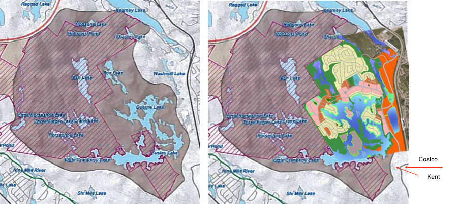
LEFT: Halifax’s vision. RIGHT: the developers’ vision, which looks like the work of a bad dentist on your favourite molar. For reference, the road at the lower right is Chain Lake Drive near Costco and Kent Building Supplies.
BMBC: developers want a big bite
Plus: two other bits of bullroar about Blue Mountain-Birch Cove Lakes
It has been about 10 years since Halifax agreed with the province to turn the Blue Mountain-Birch Cove Lakes area into a park for the generations. The deal was simple: the province would establish a wilderness area and the city would envelope it — more or less — with municipal parkland to be acquired from private landowners. Halifax’s part would serve two purposes: to provide a buffer for the protected wilderness area and a chance for people who don’t canoe or hike to have relatively easy access to nature.
Access is only 20 minutes away from downtown Halifax. You can even take the bus. And wilderness areas are not off-limits. In many cases, you can even hunt in them. But you have to leave small footprints — you can’t build roads, cottages or chop down trees.
The province did its part in 2009 but now, almost 10 years after the deal was struck, we are still waiting for Halifax to step up. The major obstacle is developers, the Annapolis Group and the Stevens Group, who want a lot more for land they own in the area than it’s worth, according to Turpin Laboratories’ assessors (details in a future post).
Misconception #1: The developers just want to keep a little land around the edges of the planned city boundary.
In fact, they want a third of it, as per the two maps above. Everything in brown on the left would either be wilderness or the proposed municipal park (the provincial area is cross-hatched). The the right is the developer vision. Everything not coloured brown would be developed. The bright green is the mandatory green space developers have to set aside when they create a new subdivision.
If you think you’ll be one of the lucky ones living there if the developers get their way, consult your financial advisor first. She may well say you can’t afford it because the demand for property next to a protected wilderness area would be high. That’s why we have parks, she’ll say — so people of ordinary means can experience nature.
Misconception #2: The municipal park boundaries have not been firmly established.
More bullroar. The infamous facilitator’s report shows them on Map 11 in the appendices. You can find the same boundaries in a 2012 report to Environment and Sustainability Standing Committee, and in the Halifax Regional Plan under Item 11.
Misconception #3: This is yet another wild-eyed attempt to be “first” or “best” at something, thus calling attention to ourselves.
Oh puh-leeze. The opposite is true. Check out Pippy Park in St. John’s; Stanley Park in Vancouver, Mount Royal Park in Montreal, Assinniboine Park in Winnipeg, the North Saskatchewan River valley parks system in Edmonton, and Fish Creek Provincial Park in Calgary. Calgary also boasts Nose Hill Park, a patch of pristine prairie similar to Blue Mountain-Birch Cove Lakes wilderness area in purpose. Sorry, but Point Pleasant Park is no match for any of them.
We at Turpin Labs think Blue Mountain-Birch Cove Lakes will be the best of all of them if the original plan is followed. But until then, we’re just playing catch-up with other Canadian cities.
Next: Who owns the contested land and what it’s worth.
